Wrangell-St. Elias National Park
“Wrangell-St. Elias National Park and Preserve encompasses the nation’s largest protected active glacial complex. Wrangell-St. Elias National Park and Preserve contains major river systems with more miles (over 1,000) of scenic, free-flowing, glacial rivers in their natural state than are found in any other protected area in the United States. The vast undeveloped expanse of Wrangell-St. Elias National Park and Preserve contains diverse aquatic and terrestrial ecosystems, ranging from alpine to marine, and providing natural habitat for populations of Alaskan flora and fauna”. – NPS Wrangell – St. Elias National Park and Preserve Foundation Statement.
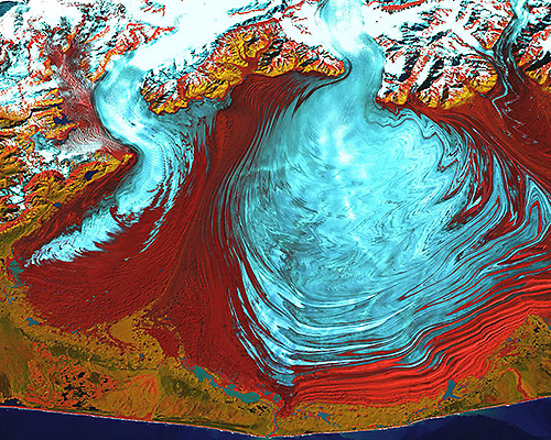
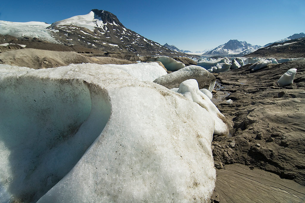
Malaspina Glacier
The first time I really got on the ice and explored the glacier, at all, was in 2011 on a trip with my friends Erin and Hig at Ground Truth Trekking. Good people.
Given its climate, latitude, and mountain terrain, Alaska is home to one of the largest areas of mountain glaciers in the world — at nearly 30 000 square miles, or 14% of the world’s total.
The glaciers of the St. Elias Range along the coast of Alaska are some of the most impressive expanses of ice in the state. The Hubbard Glacier, the Bagley Icefield, Bering Glacier, and Malaspina Glacier are among the largest and most dynamic glaciers in Alaska, and all are found within close proximity to each other, here near the Lost Coast of Wrangell–St. Elias National Park and Preserve.
Piedmont or Tidewater Glacier?
Between 1980 and 2000, Malaspina Glacier lost about 60 feet, or 20 meters, of its ice thickness. The incredible size of the glacier means that amount of ice amounts to about one-half of one percent of the total rise in global sea levels for that period. A considerable amount.
Scientists estimate that overall, glaciers and ice caps are the single biggest contributor (at more than 20% of the total) to the approximate 1.25 inches/decade of global sea-level rise.
Alaska is making the biggest contribution to this and the bulk of that is from Wrangell–St. Elias National Park and the surrounding area. Malaspina Glacier itself is a significant contributor to Alaska’s glacial ice loss.
The Malaspina Glacier has been considered, and I guess still is by most, a piedmont glacier; that is, it’s a glacier whose terminus is on land. A piedmont glacier doesn’t reach the sea. However, due to shifting patterns in climate leading to increases in coastal storms and precipitation, as well as increased coastline erosion, the Malaspina Glacier now reaches the coastline; Malaspina Glacier is now a tidewater Glacier.
Paddling a pack raft in what is now locally known as Sitkagi Lagoon, the ice cliffs of the glaciers’ terminus are clearly visible. Lying, at times, less than a foot beneath the forest floor, the ice walls are 50′ thick. As recently as 30 years ago, USGS maps show ice cliffs here of over 300′ tall; illustrating a massive decrease in the amount of ice here.
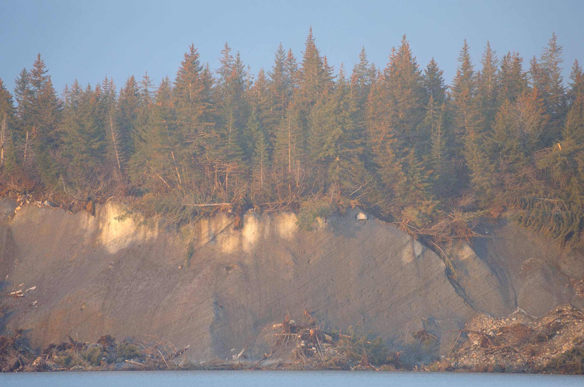
The thinnest layer of soil is enough for a spruce forest to take hold and grow, right on top of the largest glacier in North America. The wall of ice collapses into Sitkagi Lagoon and the Pacific Ocean.
Sitkagi Lagoon fills with seawater, which melts these glacial walls. The melting ice increases the volume of water in the lake, which heightens the erosion processes, carrying more silt, more boulders, more ice in and out of the lagoon. So the lagoon gets larger. The increased volume of the lake means more seawater rushes back in at high tide, further hastening the melting of the ice. And so the cycle escalates itself. The melting -> erosion -> melting -> accelerating both processes.
“Melting glaciers are expected to cause significantly more sea level rise in the future” – Read a detailed essay on climate change and Malaspina Glacier at Ground Truth Trekking – Life On Ice.
In this piece Hig points out “As glaciers shrink, they change they reduce pressure on the crust, and decrease stability of existing faults – potentially contributing to earthquakes.”
Joukaloupes
Wrangell–St. Elias National Park and Preserve is home 2 relatively famous joukaloupes.
Joukaloupe is an icelandic term (Jökulhlaup), and is used to describe any abrupt and large release of sub-glacial water.
Wrangell–St. Elias National Park is the home of Hidden Lake, and Iceberg Lake. Both lakes will typically burst mid-summer, and dramatically release tons of water, draining the entire body of water within hours. With increasing global average temperatures, increasing coastal precipitation (higher snowfalls), these processed appear to be both becoming more commonplace and and more dramatic.
Iceberg Lake, Wrangell-St. Elias National Park, Alaska.
The first time I recall seeing or hearing of Iceberg Lake draining was the summer of 1999. Of Iceberg Lake, Mike Loso, Associate Professor of Earth Sciences at Alaska Pacific University, says “There was no evidence of the lake draining at any time during the last 1,500 years …. “it appears that 20th-century warming is more intense, and accompanied by more extensive glacier retreat, than at any other time in the last 1,500 years.”.
Until recent years, this lake didn’t apparently drain at all; not it’s a yearly occurrence. Loso concludes his report “But on the northern margin of the Bagley Icefield, it appears that twentieth century warming is more intense, and accompanied by more extensive glacier retreat, than the Medieval Warm Period or any other time in the last 1,500 years.
Other Issues of Note
The Forest
Other factors that seem to be increasingly influencing the nature of the place in Wrangell–St. Elias National Park and Preserve include drastic increases in spruce beetle (Dendroctonus rufipennis) population, leading to massive die-offs in much of the spruce tree sections of the boreal forest.
Huge tracts of mature coniferous forests have become fire hazards with dead timber covering acres upon acres of land. Increases in outbreaks, both in range and frequency, have been seen since the mid-1990s, and likely a function of higher summer temperatures, and warmer, shorter winters, have affected two to three million spruce trees in south-central Alaska, even “killing all spruce trees greater than 10 centimeters (3.9 inches) in diameter in some stands” (Juday 1998, Berg et al. 2006).
Other areas of Alaska suffer similar, and worse, impacts. As well, warming temperatures cause a chain of events, “where swaths of once-permafrosted slopes have fallen away, leaving huge gouges in the streambank and dumping tons of silt into this tributary of the Copper River, the spawning ground of Alaska’s most prized salmon, the Copper River reds”.
Impact on Wildlife
Wildlife such as wolverine, who need snowbanks for the females to den in, stand to potentially suffer. Caribou face changes in their environment, as earlier plant germination no longer coincides with calving time when the caribou most require the rich food source of fresh, succulent plantlife. Increasing temperatures during the winter mean more rain, which means more ice, which makes winter forage more difficult for all ungulates, particularly caribou, who typically dig beneath the snow, in a behavior called ‘cratering’ looking for lichen.
More frequent summer fires, resulting from both the volume of beetle-kill spruce trees and ever-increasing summer storms and lightning strikes, stand to adversely affect the caribou as well. One NPS report says “Average annual temperatures in Lake Clark National Park and Preserve and Wrangell-St. Elias National Park and Preserve are predicted to shift from below freezing to above freezing during the 21st century”.
And the Birds are Affected
Seabirds are affected, too. One example is Kittlitz’s Murrelet; losing habitat as glaciers retreat, and may disappear entirely from some areas of Alaska. Kittlitz’s Murrelet populations will continue to decline as glacial retreat results in the loss of more important habitats (US-FWS 2006). Kittlitz’s Murrelets are found predominantly along the southcentral Alaska coastline, around the Gulf of Alaska.
Icy Bay is one of their primary nesting habitats in Wrangell–St. Elias National Park.
Science and Glaciers
On the Yahtse Glacier, Icy Bay: “Rising ocean temperatures are drastically influencing glacier ice loss through calving. – He found that underwater melting was responsible for over half of the ice lost at the terminus – more than the thunderous calving of ice from the glacier’s face. Motyka more recently studied the same effect on Greenland’s Jakobshavn Glacier.”
The Gulf of Alaska warmed one degree Celsius between the late 1970s and the mid-2000s
“This allows warmer ocean water to rush in and melt the entire submarine face of the glacier, greatly increasing calving icebergs and potentially resulting in a runaway retreat. This unfolding drama can last for centuries.
Such a retreat created Icy Bay itself. Just 100 years ago, the bay didn’t even exist. All five of its glaciers were merged together into one giant glacier that stretched all the way to the Gulf of Alaska; the little skiff would be buried under hundreds of feet of ice.”
This is an excellent article on research being done on Yahtse Glacier in Icy Bay, to further our understanding of climate change and glacier variation. You can listen to researcher Tim Bartholomaus from the University of Alaska Fairbanks answer some questions about this work on both the Yahtse and Kennicott Glaciers in this video below.