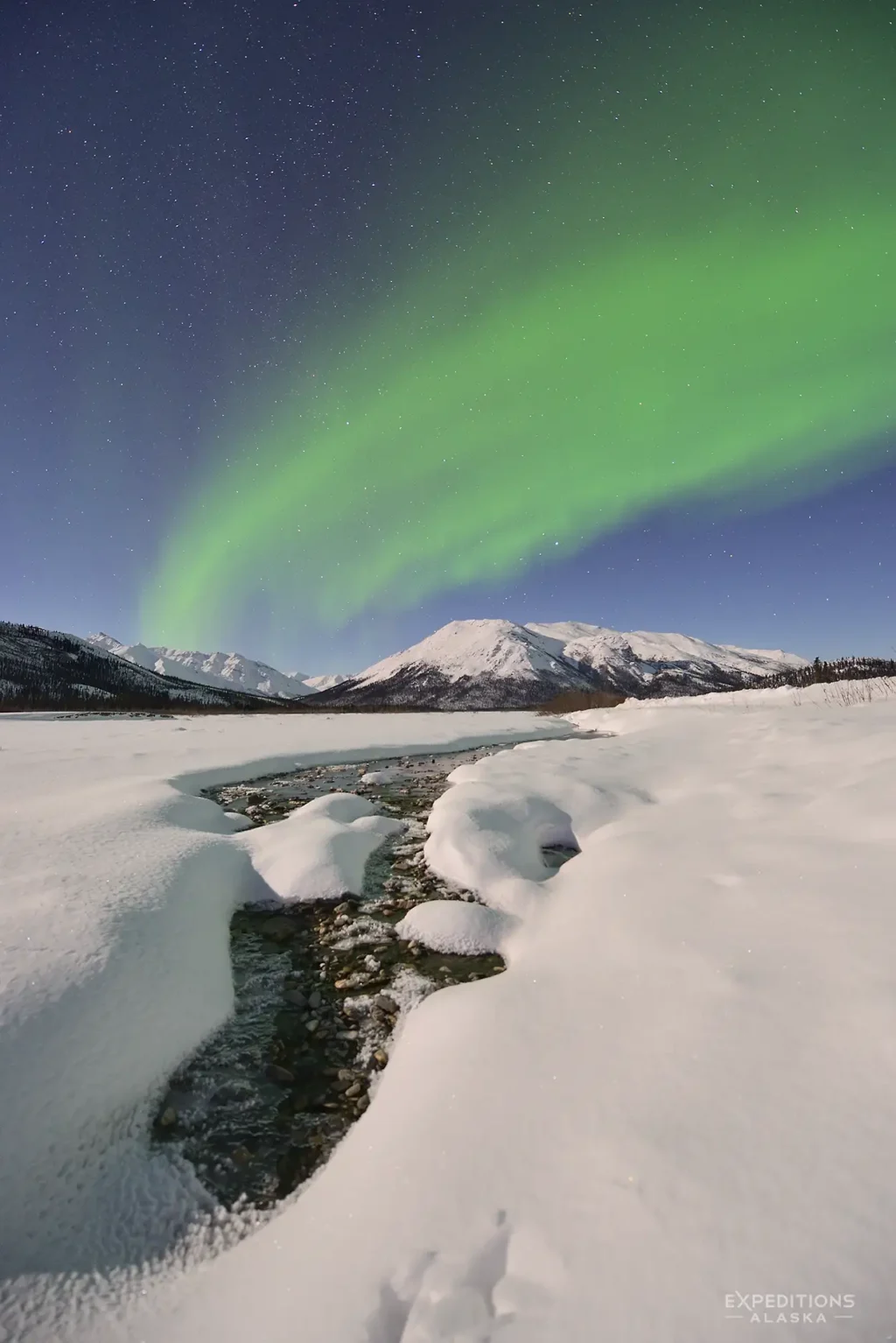
The Land - Geography and Landscape
The Brooks Range runs east-west across northern Alaska, the northernmost extension of the Rocky Mountains. Gates of the Arctic encompasses a vast section of the central range, a landscape of massive U-shaped glacial valleys, knife-edge ridges, alpine cirques, and peaks reaching 4,000 to over 7,000 feet. Marshall compared the scenery favorably to Yosemite, and he wasn’t exaggerating. But where Yosemite compresses its drama into a single valley, the Brooks Range spreads it across a territory the size of a small European country.
The Arctic Divide runs through the park, and it’s the defining geographic feature. South of the divide, rivers flow toward the Yukon and eventually the Bering Sea. North of it, water drains to the Colville River and the Arctic Ocean. That divide isn’t just a line on a map. It separates two fundamentally different worlds. The south side holds boreal forest: white spruce, birch, aspen in the valleys, black spruce and muskeg in the flats. The north side opens into true arctic tundra, where polar air dominates and trees don’t survive.
The transition between these zones is one of the most striking things about traveling here. The continental treeline passes through the park, but it’s not a clean boundary. As John McPhee described it while paddling a Brooks Range river in the 1970s, treelines in this country are digital, fingering into protected valleys, retreating from exposed ridges. Plants and animals are living on margin, in cycles that are always vulnerable to change. You walk through spruce forest along a creek bottom, climb a few hundred feet, and you’re in a different biome. The vegetation shifts under your boots in the space of an afternoon.
The park protects six designated National Wild Rivers: the Alatna, the John, the Kobuk (headwaters), the Noatak (headwaters), the North Fork Koyukuk, and the Tinayguk. These are the travel corridors, for caribou, for the people who have followed caribou through these mountains for millennia, and for visitors today. The rivers are how you move through this country, whether you’re paddling or following a gravel bar on foot. McPhee, on his Brooks Range river trip, described the water as the clearest and purest he had ever seen flowing over rocks. That hasn’t changed.
Where Marshall saw Yosemite-scale grandeur, Lopez saw something different: spare, balanced, extended, and quiet, the classic lines of a desert landscape.
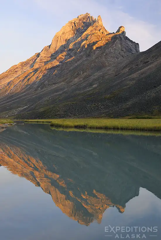
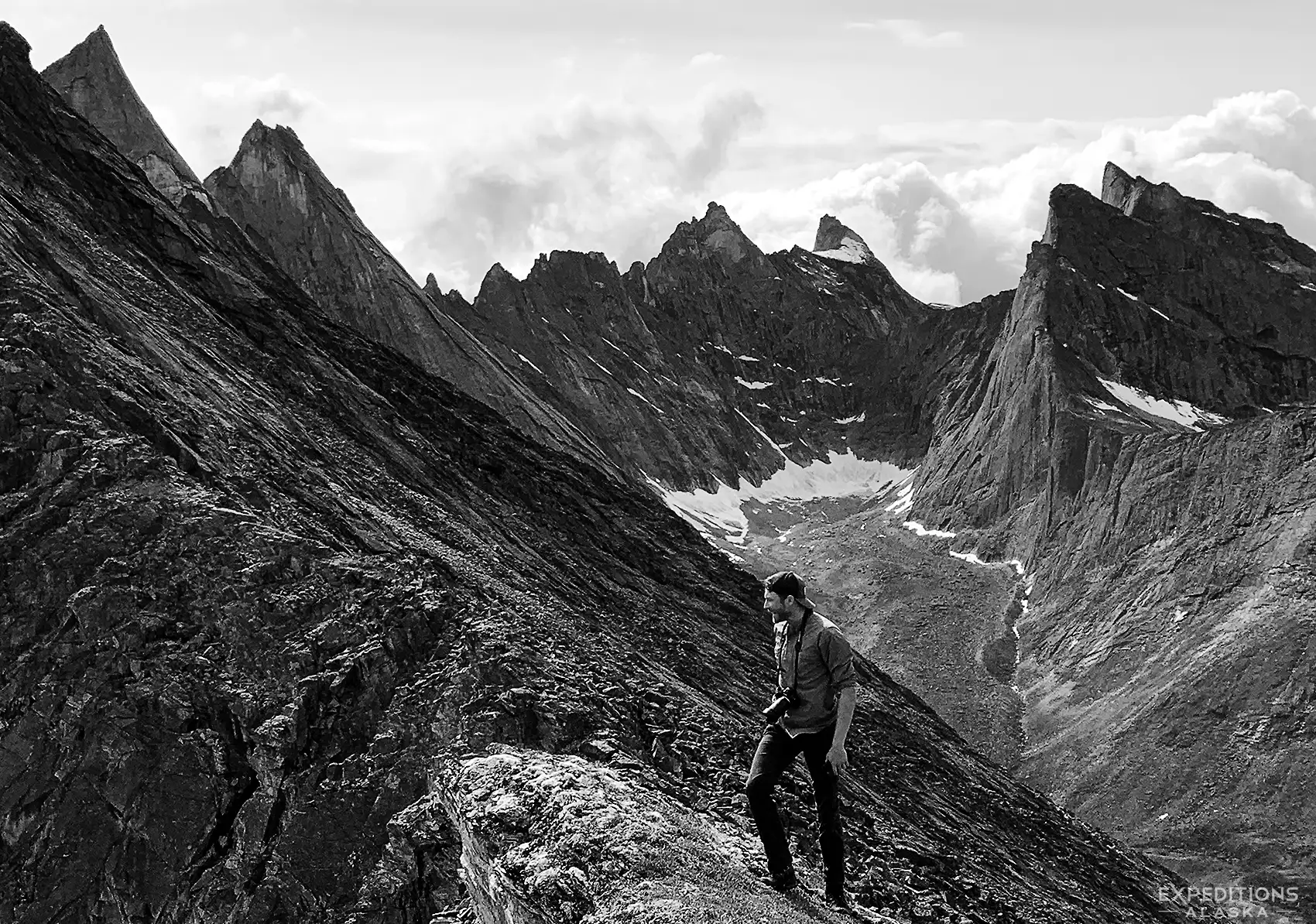
Both descriptions are accurate. In the valleys, surrounded by 3,000-foot walls of rock, the scale is overwhelming. On the tundra plateaus north of the divide, the landscape flattens into something vast and minimal, where light and weather become the primary features. The Arrigetch Peaks, a cluster of granite spires whose Nunamiut name means roughly “fingers of the hand extended”, are among the most dramatic alpine formations in North America. Marshall considered them unscalable. First climbing expeditions didn’t reach them until the late 1960s.
Wildlife
Who Lives Here
Yes, there are grizzly bears in Gates of the Arctic.
Also wolves, caribou, moose, Dall sheep, wolverine, muskox, and fox. John McPhee, camping with a group of biologists and federal planners in the Brooks Range, recounted an evening of escalating grizzly bear stories around the fire until someone finally declared that it was never a good idea to tell bear stories at night. He’d known people to wake up screaming in their sleeping bags.
That about captures the relationship between visitors and bears in this country: they are a genuine presence, you will think about them, and a healthy respect is the appropriate response.
On an August morning along the North Fork Koyukuk, our guide Jared was stretching with his group on a gravel bar when a client spotted movement upriver. A grizzly, on their side of the river.
They watched it enter the water, swim across, and climb out directly across from their camp.
No drama. No confrontation. Just mutual awareness: the bear knew they were there, they knew the bear was there, and everyone went about their business.
That’s the more common reality of bear encounters in Gates. They’re a presence, you think about them, and most of the time what you get is a glimpse at distance, tracks in the gravel, or a story to tell when you’re back in Bettles.
But the animal that defines Gates of the Arctic isn’t the grizzly.
It’s the caribou. The Western Arctic Caribou Herd’s range overlaps with the park, and these animals have been the ecological and cultural backbone of this landscape for as long as people have lived here, at least 13,000 years. The same mountain passes that caribou use during their seasonal migrations are the passes that ancient hunters used, that the Nunamiut used, and that backpackers walk through today. There is no separating the human story of this place from the caribou story.
Lopez spent time in the Brooks Range watching caribou move through, and came to think of the migrations as the land breathing. A great inhalation of light and animals in spring. The long-held breath of summer. An exhalation that pushed everything south in the fall. If you’re in the park during migration, you’ll understand what he meant. One day the valley is empty. The next, animals are moving through it in numbers that make the tundra seem alive.
If you’re lucky, you’ll coincide a trip with a caribou migration. But that’s a tough thing to predict. Usually by summer, when most of the backcountry travel we participate in, is underway, the caribou have dispersed from their massive singular herds and move through the arctic in small bands or groups, even singularly. It’s not uncommon to see a single lone caribou walking the tundra in Gates. Those big herds don’t typically stay together all summer long.
At spring breakup, migratory birds arrive from four continents (Europe, South America, Asia, and the lower 48) joining resident species in one of the great seasonal wildlife events in the Arctic. The tundra that seemed empty through the long winter suddenly hosts nesting shorebirds, raptors, songbirds, and waterfowl in concentrations that feel improbable this far north. Lopez took to bowing slightly toward the nesting birds on his evening walks, struck by the unexpected abundance of life in a place most people would call barren.
The rivers hold arctic grayling, lake trout, northern pike, and whitefish. McPhee noted that grayling seek out fast, cold, clear water. So do trout, he wrote, but grayling have higher standards. In the park’s rivers, those standards are met. These watersheds are among the most pristine in North America, and the fishing reflects it.
Climber's Heaven
13,000 Years of Human History
Lopez, writing about the Brooks Range, put it simply: you can sit for a long time with the history of man like a stone in your hand. The stillness and the pure light encourage it. He was right. There’s something about this landscape, the silence and the scale and the absence of anything modern, that makes deep time feel accessible in a way it doesn’t in most places.
People have been living in the Gates of the Arctic region for at least 13,000 years. That’s not a rough estimate or a generous reading of the evidence. At the Mesa archaeological site, located on a ridge about 150 miles north of the Arctic Circle, excavators have recovered more than 450 flaked stone tools, over 120,000 pieces of stone-working debris, and the remains of at least 40 ancient hearths. Radiocarbon dating places the oldest occupation between 11,700 and 13,600 years ago, making it among the earliest documented human sites in the Western Hemisphere. The people who camped on that mesa chose it for the same reason any hunter would: it offered a 360-degree view of the surrounding country. They were watching for caribou, musk ox, and steppe bison moving across a landscape that was transitioning out of the last Ice Age.
What makes the Mesa site remarkable beyond its age is the tool technology. The stone projectile points found there don’t resemble other ancient arctic tool traditions. They show connections to Paleoindian cultures of the Great Plains, suggesting patterns of migration or cultural exchange between interior North America and the Arctic that archaeologists are still working to understand.
The succession of cultures documented across the region spans the full arc of human habitation in northern North America: the American Paleo-Arctic tradition, Northern Archaic peoples, the Arctic Small Tool tradition (whose Denbigh culture swept from Alaska to Greenland roughly 4,000 years ago), and eventually the Athapaskan and Eskimo groups whose descendants still live here. At sites like Agiak Lake and the Ernie Creek/North Fork Koyukuk confluence, camping and hunting stations show at least 6,000 years of seasonal use. People chose these locations for the same terrain advantages (drainage, visibility, access to game) that mattered millennia ago and still matter to anyone traveling through this country today.
There’s a moment that happens on almost every Gates trip.
You’re looking for a place to camp and you find yourself reading the terrain the same way people have read it for thousands of years. The well-drained gravel bench above the flood line. The sight lines up and down the valley. The wind shelter from a low ridge.
Our guide Rhane, leading a Northern Traverse through the central Brooks Range, noted this in his trip report: groups naturally gravitate toward “easy caribou trails and gravel bars” in the Nanushuk Valley.
The caribou know the good routes. The people who hunted caribou here for 13,000 years knew them too. And when you pick your campsite, you’re making the same calculation they made.
Three Peoples, Three Strategies
At the time of sustained Western contact in the mid-1800s, three distinct cultural groups occupied the Gates of the Arctic region, each adapted to a different set of environmental conditions.
The Nunamiut, the inland Eskimo, lived in the northern Brooks Range and the valleys draining toward the Colville River. Their existence revolved around caribou to a degree that’s hard to overstate. The NPS Historic Resources Study puts it flatly: caribou provided the key to existence. Meat for food. Hides for clothing, shelter, and bedding. Bone for tools. Sinew for thread. Marrow for trail rations. When caribou herds shifted or crashed, the Nunamiut scattered to the forest edge or the coast to survive. When the caribou returned, so did they.
They traveled light. The entire Nunamiut tool kit was designed for people who moved constantly. A single skin bag (wolf, wolverine, seal, and caribou hide, sewn with sinew, ten by twenty-one inches) could hold cutting tools, drilling tools, engraving tools, hammers and flakers for working stone and jadeite, net-making gauges, cordage, raw materials, and works in progress. Everything else came from the land at hand. A skilled person could make nearly anything needed from what was available wherever they stopped.
The Kobuk River Eskimos to the west were more fish-dependent, building larger seasonal settlements along the Kobuk and traveling to the coast for the great trade fair at Sheshalik on Kotzebue Sound. That gathering drew people from Siberia to interior Alaska for trade, feasting, and alliance-making. The Upper Kobuk people, living closest to the mountains, showed pronounced cultural blending: many were bilingual in Eskimo and Athapaskan languages, with lifeways that mixed both traditions.
The Koyukon Athapaskans occupied the upper Koyukuk drainage south of the range, a country of spruce forest, muskeg, and mountain streams. They had less access to caribou than the Nunamiut, less salmon than the Kobuk people, but more moose and small game. Theirs was a marginal but diverse subsistence base. The boundaries between these groups shifted over time, and relationships between Koyukon and neighboring Eskimo communities alternated between hostility and trade, sometimes transforming through deliberate, formalized acts of peace-making that led to intermarriage and exchange.
A Complete Worldview
What connected all three groups was a relationship with the land and its animals that went far beyond subsistence. In the traditional worldview shared across the region, there was a period called Distant Time when all creatures appeared as human beings, speaking and living like people while possessing animal qualities. When the animal forms became permanent, the bonds remained. Animals had souls, power, and agency. The hunter killed to feed and clothe his family. That was understood. But elaborate practices existed to show respect, to ensure the animal’s spirit would return in another body. Waste and disrespect brought consequences.
Lopez spent years in the Arctic trying to understand this relationship. He described hunting not as an act of taking but as a state of attention, all of one’s faculties brought to bear in an effort to become fully incorporated into the landscape. To hunt, as he put it, meant to have the land around you like clothing. The focus was not killing animals but attending to the relationships that bound the hunter into the world he shared with them.
Stories carried this knowledge forward. Oral traditions, both mythic and experiential, encoded the accumulated science of place, season, weather, and animal behavior. Techniques of hunting, travel, shelter-building, and a thousand other necessities passed through generations in narratives geared to precise descriptive detail about landscape and ecological relationships. For people who traveled light across vast distances, that transmitted knowledge was itself a critical technology. Probably the most important one they had.
Anthropologist Richard Nelson, writing in 1977, identified the paradox at the heart of this place: several thousand years of continuous subsistence use had left environments worthy of preservation as the most wild and beautiful in the nation. Healthy wildlife populations. Virtually unaltered plant communities. This wasn’t wilderness despite human presence. It was wilderness sustained by a particular kind of human relationship with the land, one that Lopez would later distill to a single sentence: for a relationship with landscape to be lasting, it must be reciprocal.
The Arrigetch Peaks
Maybe the most popular destination inside the park, the Arrigetch Peaks are a spectacular hike.
Robert Marshall - The Man Who Named the Gates
The park exists, in large part, because of one person. Robert “Bob” Marshall was a forester from New York City with a PhD from Johns Hopkins, an appetite for long-distance wilderness travel, and a conviction that wild places mattered not just for the people who visited them but for everyone.
Marshall first came to the Koyukuk region in the summer of 1929. The following year he moved to Wiseman, a gold mining community of about 127 people scattered across 15,000 square miles, and stayed for thirteen months. He conducted timberline studies, explored and mapped vast stretches of unmapped territory in the central Brooks Range, and wrote a sociological study of the Wiseman community that he’d later publish as Arctic Village. He described Wiseman as “200 miles beyond the Twentieth Century” and its residents as the happiest people he’d ever met.
Marshall filled blank spaces on the map. His sketch maps and descriptions, published in a USGS Bulletin, gave names to features across the central Brooks Range: Mount Doonerak, Hanging Glacier, the Arrigetch Peaks, and dozens of others. The two peaks flanking the North Fork Koyukuk, Frigid Crags and Boreal Mountain, he called the Gates of the Arctic. That name would eventually apply to 8.4 million acres.
He didn’t do it alone. Marshall traveled with local guides and companions who knew the country: Big Charlie Suckik, a Nunamiut guide; Jesse Allen and Kenneth Harvey from the Wiseman community; and Ernie Johnson, a Swedish immigrant who lived alone on the upper North Fork Koyukuk and whom Marshall considered the most competent woodsman he’d ever encountered. Johnson’s own assessment of his life was straightforward: “I am staying out here because I like it among these ruggedy mountains better than anywhere else in the world”.
Marshall calculated the Koyukuk region’s population density at 0.0085 persons per square mile. The United States as a whole was 5,000 times denser. Manhattan was 10 million times denser. He returned for two more summers in 1938 and 1939, pushing deeper into the range. In 1935, he co-founded The Wilderness Society.
He died in 1939, age 38, of heart failure on a train. He never saw the park. It took another 41 years and the Alaska National Interest Lands Conservation Act of 1980 before the landscape he explored and named received federal protection. But the park bears the stamp of his vision: wilderness as a place of peace and purity, where the dream of remoteness and adventure beyond the paths of men could persist for the benefit of people who might never set foot in it.
When John McPhee paddled through the Brooks Range in the 1970s, nearly four decades after Marshall, he found much the same country. Marshall’s population density numbers still essentially held. The landscape had not been altered. That continuity, across Marshall’s explorations, McPhee’s river trips, and the present day, is itself a kind of testimony to what the park was established to protect.
Anaktuvuk Pass - The Village Inside the Park
There is one permanent community inside Gates of the Arctic National Park. Anaktuvuk Pass sits at 2,200 feet on the divide between the Anaktuvuk and John Rivers, a historic caribou migration corridor through the central Brooks Range. The name means “place of caribou droppings”. It is not a tourist town.
The village is home to the Nunamiut, the same inland Eskimo people whose ancestors hunted caribou through these passes for thousands of years. The original nomadic Nunamiut scattered from the Brooks Range in the early 1900s when the caribou population collapsed. In the 1940s, several families returned, drawn by the land and the recovering herds. By 1949, a more permanent settlement formed around the desire for a school and a post office. The community was incorporated in 1959.
Today, roughly 325 to 400 people live here. It’s a dry village with no alcohol sales or possession. Employment is heavily public sector, with the North Slope Borough and the school district as major employers. The Nunamiut Corporation runs the local store. There’s a health clinic, a school serving preschool through twelfth grade, and the Simon Paneak Memorial Museum, which houses exhibits on Nunamiut history, traditional tools and clothing, and cultural artifacts. Residents maintain a strong tradition of finely crafted caribou skin masks.
The community’s relationship with the national park is complicated, and visitors should understand that. When Gates of the Arctic was established in 1980, it was done without the consent of the local people. The village found itself surrounded by federally protected land. Much of the area immediately around Anaktuvuk Pass is owned by the Nunamiut Corporation or the Arctic Slope Regional Corporation, not the federal government. Access to these lands without permission is trespassing. The Corporation holds an easement for ATV use on some federal non-Wilderness lands near the village, so visitors may encounter motorized vehicles in the area.
Day tours operate from Fairbanks, a small plane flight followed by roughly an hour of guided touring in the village. The Anaktuvuk Park Ranger Station can provide backcountry information. Expect limited hours and significantly higher prices for everything. This is one of the most remote communities in North America.
Lopez, during his time in the Brooks Range, described the country around Anaktuvuk Pass: the pitched massifs, the willow-lined banks of the John River flowing south, the flat tundra opening north. It’s landscape that people have oriented their lives around for millennia. The village is the living proof that they still do.
ANILCA and the Management of the North
The legal existence of Gates of the Arctic is defined by the Alaska National Interest Lands Conservation Act of 1980, commonly known as ANILCA. This was a landmark piece of legislation that attempted to balance the preservation of massive ecosystems with the existing rights of rural Alaskans. It is the reason the park is split into a National Park and a National Preserve.
The management of the park is dictated by Title VIII of ANILCA, which protects subsistence hunting and gathering for local, rural residents. In the National Park sections, sport hunting is strictly prohibited. Only those with a documented history of subsistence use are allowed to hunt caribou, moose, and Dall sheep. In the National Preserve sections, sport hunting is permitted under state regulation. This creates a complex regulatory landscape that can be confusing for visitors.
ANILCA also designated six “Wild and Scenic” rivers within the park boundaries. This is a technical protection layer that ensures the headwaters of the Noatak, the Kobuk, and the Alatna will never be dammed or diverted. The legislation was born out of intense conflict between federal oversight and the fierce independence of Alaskans. As John McPhee documented, the creation of the park was seen by many locals as a “federal land grab.” Today, that tension has evolved into a cautious cooperation, but the rules remain unforgiving. The park is managed to maintain its “wilderness character” above all else, which means no permanent structures, no motor vehicle access in the park proper, and a management philosophy that prioritizes the “natural processes” over human convenience.
Getting There
There is no easy way into Gates of the Arctic.
That’s the point, and it’s also the first practical reality every visitor has to deal with.
The park has no roads, no entrance stations, no shuttle buses, no maintained trails. Access is almost entirely by bush plane, typically a small aircraft on floats or tundra tires, typically chartered out of Bettles, Coldfoot, or Fairbanks. You fly in, land on a gravel bar or a lake, and the pilot leaves. Getting picked up at the end of the trip means being at the agreed location on the agreed date, weather permitting.
The one partial exception is the Dalton Highway, which skirts the park’s eastern boundary. A few entry points along the highway allow hikers to walk into the park on foot without a charter flight. This is the most affordable way in, but it limits where you can go and still requires significant backcountry experience.
Bettles is the most common staging point for bush plane access into the central Brooks Range. It’s a small community about 35 air miles from the park boundary, reachable by scheduled flights from Fairbanks. Several air taxi operators work out of Bettles, and the NPS ranger station there is the primary contact for trip planning and backcountry information. Coldfoot, on the Dalton Highway, serves as a secondary staging point.
The cost is real. Bush plane charters are not cheap, and they’re the largest single expense for most Gates of the Arctic trips. McPhee, writing about the Brooks Range in the 1970s, described a wildlife biologist in Anchorage who knew the wilderness was out there, hundreds of millions of acres of it, but couldn’t afford the air charter to reach it. His soul, McPhee wrote, began to stale. That tension hasn’t changed. The access barrier is part of what keeps the park wild, and it’s also what makes planning and budgeting essential.
Weather in Gates can mean almost anything. We’ve had August trips where our guide Jule reported “relentless sun, hot most days” with virtually no rain. We’ve had August trips where guide Rachel wrote simply “wet wet wet” in her report. Same month, same valleys, completely different experiences.
What’s consistent is that conditions can change fast and you need to be ready for both ends of the spectrum. Our guide Ayla, leading a late summer trip that included days of flooding rain followed by clear skies, captured it in her notes: “the mystical weather and lighting.” Both the challenging days and the spectacular ones are part of what this place is.
Most visitors to Gates of the Arctic go with a guide. This isn’t just marketing. Route-finding in trailless terrain above the Arctic Circle, river crossings, bear country protocols, weather judgment, and the simple logistics of resupply and extraction in a place with no infrastructure all require experience that most people don’t have. Independent trips are possible for experienced wilderness travelers, but the margin for error is thin and the consequences of poor decisions are serious.
When To Visit
The backpacking and packrafting season in Gates of the Arctic runs roughly from mid-June through mid-September. Within that window, conditions change significantly.
Late June through mid-July brings continuous daylight above the Arctic Circle. The sun doesn’t set. It circles the sky in a long horseshoe, and the light it casts is extraordinary. McPhee, paddling a Brooks Range river in midsummer, described it as the rich kind of light that in more southern places only comes at evening, heightening walls and bringing out of things the beauty of relief. That quality of light, which you’d normally get for twenty minutes around sunset, lasts all day. The tradeoff: mosquitoes are at their worst, snow may still block higher passes early in the window, and river levels can be high with snowmelt.
Late July through mid-August is generally considered prime season. Mosquitoes diminish. Blueberries ripen across the tundra. The tundra itself begins shifting toward fall color. Days are still long, though no longer endless. Temperatures are typically in the 50s and 60s during the day, sometimes warmer, with nights cooling into the 30s and 40s.
Late August through mid-September brings fall color, the first dusting of snow on higher peaks, and the possibility of northern lights as darkness returns. Caribou migration picks up. Temperatures drop. Days shorten rapidly this far north, and the weather window for bush plane access narrows. Freeze-up typically arrives in October, but conditions can deteriorate well before that.
Regardless of when you go, be prepared for weather that can change fast. Rain, wind, and cold snaps can happen in any month of the summer season. Snow is possible at any elevation in any week. The Brooks Range is not a place where you can count on a forecast holding.
Our trips start and end with what the weather says. As much as we’d love to go do the Northern Traverse in mid June, the lakes we start from and finish at are usually frozen solid, unthawed until late June. So that’s the earliest we start there.
Earlier dates (second week of June) we can get in for the Arrigetch or Alatna River trips. Beyond the Gates is another variable, with gravel bars coming and going with spring melt rivers.
Typically we’re done guiding trips in Gates of the Arctic by early Sep, though we have done as late as mid-Sept before.
It’s the arctic; we’re always playing the whims of the weather here.
Gates of the Arctic FAQs
-
Is Gates of the Arctic worth visiting?
If you’re looking for a national park with scenic overlooks, interpretive signs, and a gift shop at the trailhead, Gates of the Arctic is not the place. But if you want to experience genuinely wild landscape on its own terms, with no trails and no crowds, this is as close to that as you’ll find in the United States. Fewer than 11,000 people visit the park in a typical year. Most national parks see that many visitors in a single afternoon.
-
How do I get to Gates of the Arctic?
The most common route is to fly from Fairbanks to Bettles on a scheduled flight, then charter a bush plane into the park. Some visitors access the eastern edge of the park on foot from the Dalton Highway. There are no roads into the park and no entrance stations. See this section above for details on logistics and costs.
-
Do I need a Guide?
You don’t legally need one, but most visitors use a guide, and there are good reasons for that. Gates of the Arctic has no trails, no signage, no cell service, and no rescue infrastructure. Route-finding, river crossings, bear safety, and weather judgment all require backcountry skills that take years to develop. If you have extensive wilderness experience in remote, trailless terrain, an independent trip is possible. It can be super rewarding. If you don’t, go with a guide.
We’ve been guiding trips in Gates of the Arctic for over two decades, and it’s one of the places we know best. From the eastern edges of the park to the western border near Kobuk.
My favorite? The Northern Traverse. It’s a challenging, burly walk that never quite feels like it’s under your feet. But for an easier trip, the Arctic Sampler, a customized basecamp west of there is a great option.
-
Do I need a permit?
No permit or reservation is required for backcountry travel in Gates of the Arctic. The NPS does ask that you contact a ranger station before your trip, both for safety and to help them track use patterns. Ranger stations in Bettles, Coldfoot, Anaktuvuk Pass, and Fairbanks can provide current conditions and trip planning assistance.
-
When is the best time to visit?
Late July through mid-August is the most popular window: long days, diminished mosquitoes, warm temperatures, and the start of fall color. But every part of the summer season has something to recommend it. See Section 8 above for a detailed breakdown by month.
-
What books should I read before going?
Four books will give you a deeper understanding of this place than almost anything else:
Barry Lopez, Arctic Dreams (1986). The definitive meditation on Arctic landscape, wildlife, and human perception. Lopez visited Anaktuvuk Pass and spent extensive time in the Brooks Range. National Book Award winner.
John McPhee, Coming into the Country (1977). Part I follows a canoe trip down a Brooks Range river. Precise, sensory writing about the physical reality of being in this landscape. Published three years before the park was established.
Robert Marshall, Alaska Wilderness. Marshall’s own expedition journals from the explorations that led to the park’s naming and eventual protection.
William E. Brown, Gaunt Beauty… Tenuous Life (1988). The NPS Historic Resources Study. The most comprehensive historical narrative about the region. Available free online through NPS.
Nicholas J. Gubser, The Nunamiut Eskimos: Hunters of Caribou (1965). The foundational ethnography of the inland Eskimo people who still live in Anaktuvuk Pass. Based on fieldwork in the late 1950s, it documents the subsistence patterns, social life, and worldview that shaped human experience in this landscape for millennia.
All Four Seasons