A trip report from one of my favorite guided backpacking trips: The Goat Trail and a hike down Chitistone River.
One gorgeous evening, involving a 2 mile hike (one-way) from camp and I was able to capture some more photos that I had been hoping for some time now to make. Lucky me!
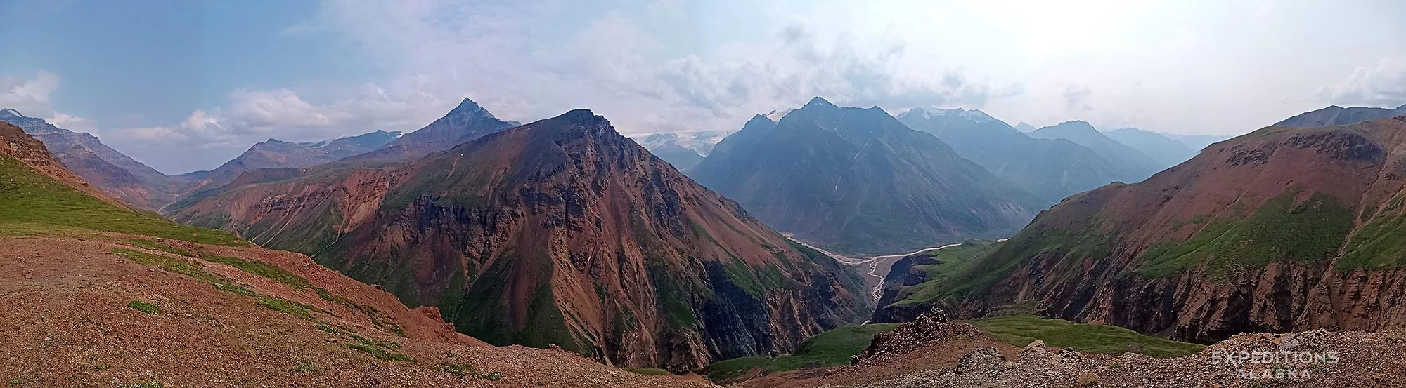
The group I was guiding were backpacking from Skolai Pass, in Wrangell St. Elias National Park and Preserve, to ‘Wolverine‘, a landing strip high above the Chitistone Valley, over the relatively popular ‘Goat Trail‘. That route is the first backpacking trip I ever took in the park, and one we’ve been guiding now for 25 years. I love this route.
This is a classic hike, and one we try to make every summer. Before I talk about it further, I’ll qualify what I mean by ‘popular’ here.
Probably not 50 people hike this route each year. More likely 40, at most. Consider, for example, that nearly TWO THOUSAND people venture to hike the entire Appalachian Trail each year, and one starts to see that the word ‘popular‘ is entirely contextual. I only say ‘popular‘ here because so few people hike anywhere else in Wrangell-St. Elias National Park.
We had a real mix of weather on this trip, so I was lucky to grab such a gorgeous evening here at this location. The clouds dissipated throughout the course of the day. We spent the afternoon backpacking across the Goat Trail, a steep sloping scree-sided series of ravines, traversed by a meandering myriad sheep and goat trails; hitting the correct trails and lines makes a huge difference on how easy, or even how possible, the traverse is. The ‘wrong’ ones can easily be impassable for people, especially those carrying heavy backpacks. Been there, done that.
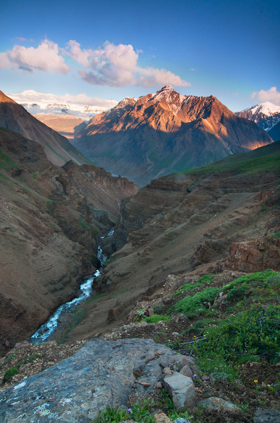
As we enjoyed dinner on a ridge high above the Chitistone River, the evening grew more and more lovely. Given how nice the light was looking, I knew I had to make the hike down toward the river for some photography. The view across the valley to the University Range to the south of us glowing in the late Alaska light is just gorgeous.
I don’t know exactly how far it was from camp to my final objective, but it’s over 2 miles, and quite a few feet of altitude loss (gain on the return hike). The walk down took close to an hour and the return, after sunset, was a bit of a mission. on the whole, though, well worth the effort. I’d long wanted to get some shots from this locale, and couldn’t let such an opportunity pass me by.
I shot some photos of Chitistone Falls, as well as this unnamed gorge that enters into the Chitistone just downstream from the falls. The University Range, featuring Mt Bona (16 421′) and Mt Churchill (15 ‘) to the south provide a classic mountain backdrop. I managed to grab some images of those awesome mountains later in the evening, purple with rich alpenglow. I’ll post one in a few days.
Possibly the oddest thing about this evening walk was the wildlife I ran into. High above treeline, barely in brush line, I saw a porcupine.
Too cool.
That’s pretty unusual in the high country. I’ve been backpacking these routes here in Alaska, and guiding them every year, and this is the first and only porcupine I’ve seen up above treeline. He was just hanging out in the brush, gnawing on some willow and alder.
Both of us got a little surprise, I think.
The view to the south from my little overlook is spectacular.
The Goat Trail is such a great hiking route. It’s got enough challenge to meet the adventure threshold for just about anyone. There are plenty of awesome little explorations along the way. This is one of my favorite things about the Goat Trail. Every single time I backpack this trip, with decades of guiding it,I see some spot or little part of it I think “oh man, next time I gotta go check THAT out. And that’s just on my side of the river.
And it’s like this along the entire route. I’ve landed at the Skolai Pass strip, and hiked north around Mt Baldwin to see the views of that area; My Regal, the Nizina Drainage, Mt Blackburn are all visible on a nice day. North east past Skolai Creek Falls and down to the toe of Frederika Glacier.
Backpacking south to Chitistone Pass I’ve walked through the marshy lowlands on old bear trails, higher up across the moraine right below the Skolai Bluffs and checked out the Three Falls up there. On to upper Skolai Lake, the face of Russell Glacier to this very cool little plateau I call “Great Bear Valley” (because we see a bear or bears there every single time we backpack it), across Russell Glacier. I’ve walked every which way I can find thru Chitistone Pass. Saw the first grizzly bear I ever saw right at the entrance to the pass (she and her cubs scampered off to the south).
I’ve guided backpacking trips here where we led the group down to the floor of Chitistone River, crossed the river, on down across Toby Creek, and got picked up at Glacier Creek. That’s a super cool walk, but the river crossings can be sketchy. Careful there. Because of that, and a couple other reasons, we normally lead our guided trips up higher after the Goat Trail and make our way to Wolverine.
Wolverine is a sweet little ridge high above the Chitistone River, with really special views in all directions. It can get windy up there, so be judicious with your choice of camping there.
En route to Wolverine, from Chitistone, there are a couple of ways to go. On personal backpacking trips, I like the north side of the butte, overlooking Nizina again. Guiding newer backpackers here however, my preference is to stick to the shorter route.
And the explorations aren’t done there. From Wolverine there are several days worth of really nice exploring, walking west or northwest. Grotto Creek is a favorite of ours to poke around.
If I have time, and we usually don’t, I like to backpack up to the headwaters of Grotto Creek drainage. It’s easy to spend at least two nights up there. There’s just so much to explore and see right around there. Then it’s a short, easy walk back down over to camp near the strip and wait for our pickup on the final morning.
The Goat Trail is one of our favorite backpacking trips. It’ll always hold a soft spot in my heart because it was my virgin Alaska backpack. It’s got a little something of everything. Easy peezee, sweet campsites, a little gnar, a little sketch, and always something different.
We guide this route every summer. If you’re interested in having us guide you on this route, reach out for info.
Join Our Newsletter
Stay up to date with all the latest goings on as well as information and notes from the field with Expeditions Alaska. The magnificent newsletter "Ramblings" ~ It's like having Alaska land in your inbox.
"*" indicates required fields