North of Everything
The floatplane banks over Circle Lake and you see the Arrigetch Peaks for the first time from the air. Granite spires stacked against the sky, walled off behind miles of spruce forest and muskeg. From the lake, you can’t see them at all. You just know they’re up there.
The pilot cuts the engine, the floats touch the water, and within a few minutes you’re standing on the shore with your pack and your group, watching the plane shrink to a dot over the Alatna River valley. Then it’s quiet. Properly quiet. The kind of quiet where you hear your own breathing and the water lapping and absolutely nothing else.
That’s how every Arrigetch Peaks backpacking trip starts. A lake, a pile of gear, and a long walk ahead.
The Approach
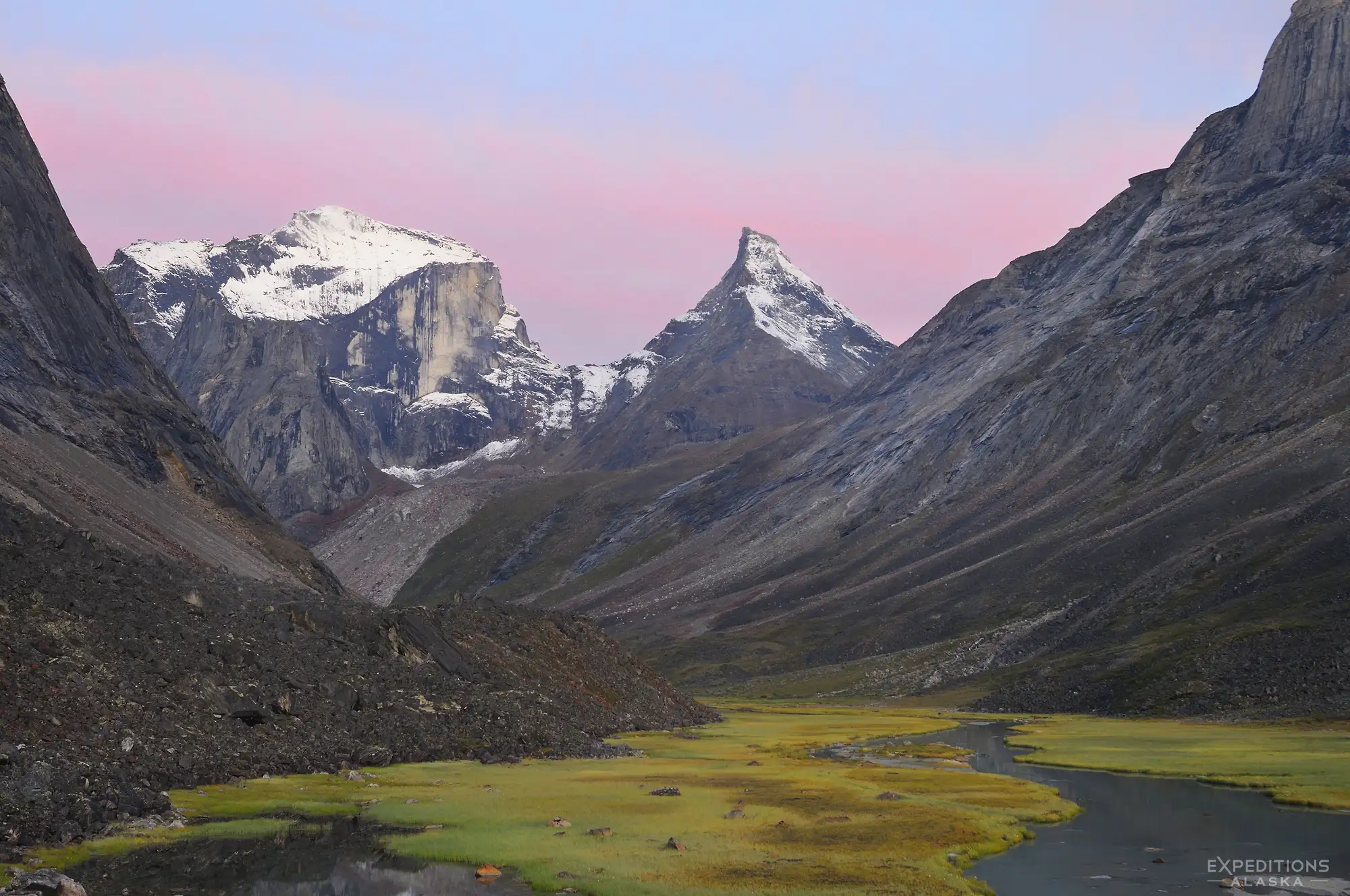
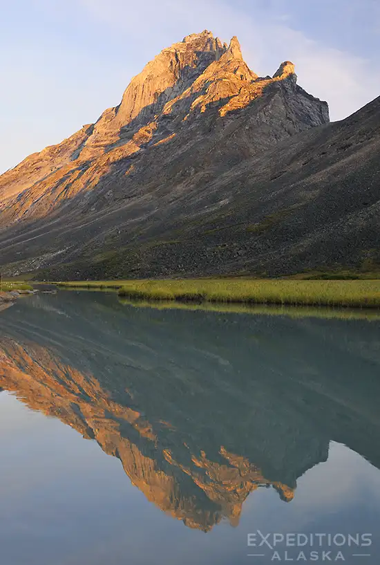
The Arrigetch Peaks sit in the central Brooks Range, inside Gates of the Arctic National Park. The name is Inupiaq, meaning roughly “fingers of the hand extended”, which is about as accurate a description of a mountain range as you’ll ever hear. From a distance the peaks look like a granite hand reaching out of the tundra.
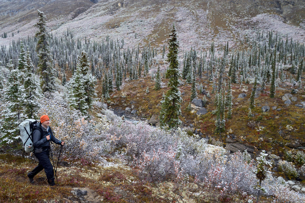
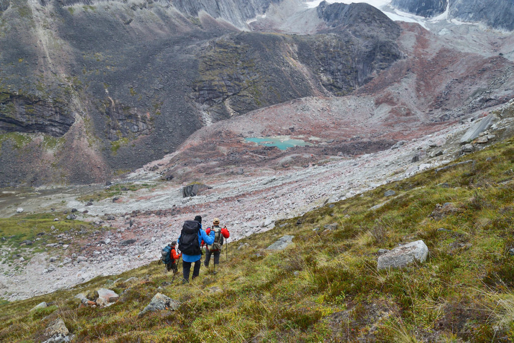
Getting to them takes work. From Circle Lake it’s roughly 10-12 miles to the alpine valleys beneath the peaks, and none of it is on trail. There’s a social trail that other hikers and animals have worn into the landscape over the years, but finding it from the lake isn’t obvious, and losing it is easy. The first stretch involves creek-crossing shoes, wet feet, and some bushwhacking through willow and spruce. Muskeg too. The tussocks are a rite of passage. Those lumpy balls of grass that tip sideways when you step on them and threaten to roll your ankle with every stride. Everybody complains about the tussocks. If you’ve read our hiking guide for Gates of the Arctic, you already know the terrain up here is a different animal than Lower 48 backpacking.
We typically break this into a couple of days of walking, with a camp in the spruce before pushing into the alpine. There’s no need to rush it. The walking gets dramatically better once you clear the treeline and reach the open tundra and boulder fields of the upper valleys.
The Peaks
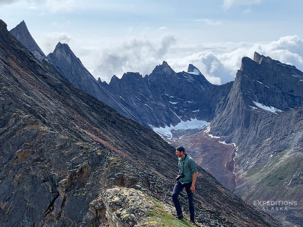
Robert Marshall explored this country in the 1930s and called the Arrigetch Peaks “a series of unscalable needle peaks such as probably cannot be duplicated anywhere else in the world”. He wasn’t entirely right about the unscalable part (climbers first reached them in the late 1960s), but his instinct about the scenery holds up. The granite walls rise 2,000 to 3,000 feet from the valley floors. Spires, towers, cirques, and hanging glaciers. Peaks with names like Caliban, Ariel, Xanadu, Shot Tower, the Maidens, Badille, Wichmann Tower, the Citadel, and Slot Tower.
As the peaks come into view, people want to know what they’re looking at. Fair enough. The names come from the climbing parties who first reached these walls in the late 1960s, and they stuck. You’ll hear us pointing them out as we walk. The scale is hard to process at first. You think you’re close to the base of a wall, and then you walk for another hour and it’s still up there above you.
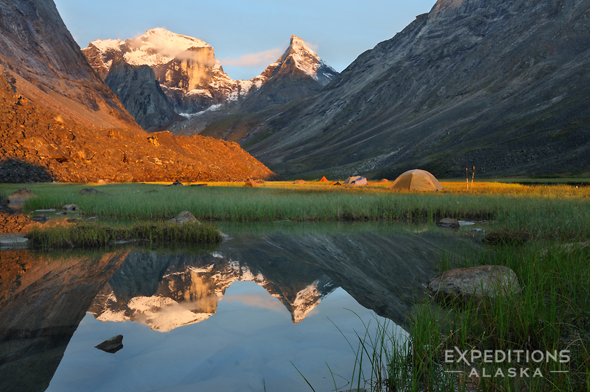
We set up a basecamp in the upper valley and spend several days hiking into the surrounding drainages. This is the heart of the trip, and the reason people keep coming back.
Valley of the Maidens
The Maidens are a pair of granite spires that tower over their own drainage. Getting there from basecamp involves a creek crossing at the confluence with Arrigetch Creek, then a walk through grassy meadows toward the mountain wall that separates the Maidens from the main valley. The walking is good once you’re up. The granite is right there, close enough to study the climbing routes and wonder what kind of person looks at a 2,500-foot vertical wall and thinks “I’ll have a go at that”.
Up in the Maidens drainage you can get hands-on with some of the geology. Strange gold-colored dikes cut through the granite spine of the Arrigetch, crumbly and calcareous, visibly different from the hard grey granite around them. Seeing them up close helps you make sense of the bigger, more dramatic dikes visible on the faces of Wichmann Tower and Melting Towers further up the valley. There are also low-angle slabs at the base of Camel Peak that are fun to mess around on if your group is comfortable with a little easy scrambling.
From the ridgeline above the Maidens you can see all the valleys at once. One of our guides made the scramble up a smaller peak in light snowfall, looked back at the Maidens from the top, and said it was the single best view of the whole trip. That tracks. Get yourself above the valley floor here and the perspective changes completely.
Aquarius Valley
If the Maidens are dramatic, Aquarius is where the Arrigetch gets beautiful in a quieter way. Alpine tarns, turquoise lakes, a glacier tucked into the headwall. The further you walk into Aquarius, the more it opens up. We usually hike until we can see the glacier and the uppermost tarn, then sit and eat lunch for as long as anyone wants to stay. Bring extra snacks. You’ll want more time up here than you think.
If you make it to the fourth lake, it’s worth walking to the west end where you can look straight at the full face of Badille. That alone is worth the extra distance.
On clear days Aquarius is stunning. On cloudy days, when the fog sits in the cirques and the light goes flat and grey, it’s a different kind of stunning. One of our guides described the weather up there as “mystical”. That’s not the word I’d normally reach for, but she’s not wrong.
The Main Valley
Arrigetch Creek itself runs through the main drainage, and following it upstream leads to the big walls. Shot Tower, Xanadu, the whole collection of granite that makes climbers lose sleep. For backpackers, the appeal is more pedestrian (literally). You can walk up the valley floor, staying on boulder fields and lateral moraine, and get close to the peaks without technical climbing. The terrain can be deceptive. Cotton grass makes the valley floor look wetter than it often is, and the moraine scrambling can tire out less confident rock-hoppers. We’ve found that staying low on the return is often easier than the high route, even when it looks soggy from above.
The upper valley rewards those who keep going. Push past the last knoll where the valley bends southwest and you get views of the remnant glaciers and the roll heading into Ariel Pass. On one trip, the stronger hikers continued up to the pass itself, and it turned into the high point of their whole trip. Good light, wide views of the glaciers and the creek dropping away below. Even if you don’t make it all the way to the pass, walking toward it is worth the effort.
This is also where you might witness the mountain doing what mountains do. We watched an enormous rockfall come off the eastern gendarme of Caliban one afternoon. Later, we hiked up to the hanging valley beneath it and ate lunch near the lake, tracking where the biggest boulders had bounced and come to rest. The lake itself had drained and was more of a muddy pond, but the evidence of the landscape actively reshaping itself was everywhere.
On another trip, a grizzly spent the afternoon chasing ground squirrels in the alpine above us. Just running around, digging holes, completely uninterested in our group. That’s a pretty standard Arrigetch wildlife encounter. The bears are here, they’re a genuine presence, and mostly they’re doing their own thing. On a different trip, a bear cub wandered within 25 yards of camp before spotting us and bolting. We spent the next couple of hours watching it, its sibling, and their mother through the spotting scope across the valley.
Weather
You’ll hear people say the Brooks Range weather is unpredictable and they’re right, but that’s not quite the whole picture. It’s more accurate to say it’s variable. You might wake up to frost on your tent and be hiking in a t-shirt by noon. One trip can see snow on the first day, rain on the second, a hard freeze overnight, and bluebird skies by day three. Late August trips sometimes get fresh snow above 4,500 feet with fall colors already taking hold in the valleys below. Early summer brings relentless sun and warmth, which also brings bugs. We’ve also had trips where we never set up or took down a tent in the rain. It happens. Don’t count on it.
We tell people to prepare for all of it. Good rain gear, warm layers, sun protection, and the mental flexibility to enjoy a tent day if the weather pins you down. Some of the best camp conversations happen on weather days.
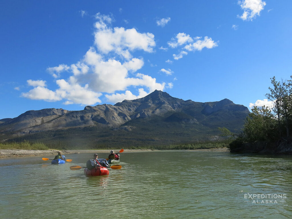
The Packraft Out
We stash our packrafting gear at the landing zone when we first fly in. After 7 or 8 days in the peaks, coming back down to Circle Lake and transitioning from hiking boots to a packraft feels like a second trip starting. The energy shifts. People who spent a week grinding over boulders and tussocks suddenly have a paddle in their hands and a different kind of wilderness unfolding around them.
The Alatna River is easy water. Class I, flat, and clear enough that you can watch the bottom slide past. We paddle from Circle Lake through a slough (expect a couple of portages around beaver dams) and onto the Alatna, then float downriver to our takeout. It’s relaxed paddling with headwinds and lunch breaks and animal tracks on every gravel bar. Side streams like Hot Springs Creek hold grayling, and the evening fishing is worth the detour. The transition from walking the alpine to floating the boreal forest, with the peaks shrinking behind you, is one of the best sequences in any trip we run.
Our floatplane picks us up at Takahula Lake after a short portage from the river. Takahula itself is worth a half day. We’ve had beautiful afternoons there, paddling around, fishing, swimming, just soaking in the last of the backcountry before heading back to civilization. Then it’s back to Bettles for a shower, a meal, and the strange re-entry into a world with walls and ceilings.
Who This Trip Is For
This isn’t a beginner backpacking trip. The terrain is rough, the loads are heavy (you’re carrying 8-10 days of food plus group gear), and the hiking conditions in the approach and lower valleys are legitimately challenging. Tussocks, creek crossings, and boulder fields are the norm, not the exception. We rate this trip a 3-4 out of 5 on our difficulty scale, and we tell people to assume it’ll be one notch harder than whatever they’re expecting.
That said, you don’t need to be an elite athlete. You need to be fit, experienced with multi-day backpacking, and comfortable being uncomfortable for stretches. Wet feet, cold mornings, heavy packs. If that sounds miserable, this isn’t your trip. If that sounds like the price of admission to one of the most spectacular mountain landscapes in North America, then it probably is.
All of our Gates of the Arctic backpacking trips launch from Fairbanks. We fly to Bettles, check in with the National Park Service, and fly into the backcountry from there. All scheduled 2026 departures include the packrafting extension.
Follow Us
Stay up to date with all the latest goings on as well as information and notes from the field with Expeditions Alaska. The magnificent newsletter "Ramblings" ~ It's like having Alaska land in your inbox.
"*" indicates required fields